London's expansion from a mid-19th century administrative hub into a sprawling Southwestern Ontario city brought with it a cascade of geotechnical challenges that few outside the industry appreciate. The downtown core sits atop a complex stratigraphy of glacial till and lacustrine deposits left behind by the retreat of the Laurentide Ice Sheet, while the newer subdivisions pushing into the city's northwest edge encounter the silty clay plains of the former glacial Lake Whittlesey. When infrastructure stretches across such varied terrain, verifying that fill materials and structural backfill have been placed at the specified density becomes a non-negotiable step. The sand cone method, standardized under ASTM D1556, offers a straightforward yet rigorous way to measure in-place density, and it remains the benchmark for compaction control on projects from the Bostwick Road extensions to commercial pad construction near Highway 401. In our experience, skipping this verification step because 'the compactor made enough passes' is precisely how differential settlement problems begin.
In London's glacial till, a passing density at the surface can mask a moisture-related compaction failure just 30 cm down—only a sand cone test reveals the full picture.
Our approach and scope
Site-specific factors
What we see frequently in the London area is that contractors working in the tight clay soils east of the Thames River will achieve surface compaction that looks and feels solid, but just a few inches down the density drops off sharply because the moisture content wasn't within the optimum range during placement. The sand cone test exposes this condition immediately. On one recent project near the Fanshawe Park Road corridor, a series of sand cone readings taken at 30 cm depth revealed densities hovering around 88% of Standard Proctor maximum, well below the 95% typically specified for structural fill under footings. The root cause was the silty clay's sensitivity to the narrow moisture window dictated by the Proctor curve—something only a field density test can quantify. If these low-density zones go undetected beneath a slab-on-grade or an asphalt pavement, the long-term settlement can easily exceed the serviceability limits for floor tolerances or pavement smoothness specified in OPSS 501. For projects where the subgrade is marginal, we often coordinate the plate load test to correlate the density readings with the actual modulus of subgrade reaction, giving the structural engineer a more complete picture of the soil-structure interaction.
Applicable standards
ASTM D1556 - Standard Test Method for Density and Unit Weight of Soil in Place by Sand-Cone Method, ASTM D698 - Standard Test Methods for Laboratory Compaction Characteristics of Soil Using Standard Effort, ASTM D1557 - Standard Test Methods for Laboratory Compaction Characteristics of Soil Using Modified Effort, OPSS 501 - Ontario Provincial Standard Specification for Compacting, CSA A23.3 - Design of Concrete Structures (referenced for compaction under slabs)
Other technical services
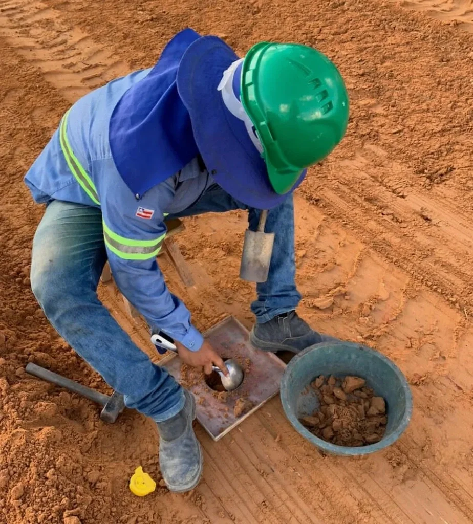
In-Place Density Testing (Sand Cone Method)
On-site compaction verification using the ASTM D1556 sand cone method for structural fill, utility trench backfill, road subgrade, and engineered fills. Each test includes field moisture content determination and a comparison to the laboratory Proctor curve, with results delivered within 24 hours.
Compaction Control Program Support
Development of site-specific compaction specifications, establishment of testing grids and frequencies, and coordination of laboratory Proctor testing (Standard and Modified) to create the reference density benchmarks required for interpretation of field density results.
Typical parameters
Quick answers
How much does a field density test using the sand cone method cost in London?
For projects in London and the surrounding Middlesex County area, a single sand cone density test typically falls in the range of CA$140 to CA$180 per point, depending on the number of tests required, site accessibility, and travel distance. Most earthwork projects require multiple test locations across each compacted lift, so the total cost scales with the area being placed. We provide a detailed quote based on the testing frequency specified in your project documents.
What is the difference between the sand cone method and a nuclear density gauge?
The sand cone method is a direct volumetric measurement: you physically excavate soil, weigh it, and measure the hole volume with calibrated sand. A nuclear gauge estimates density indirectly by measuring the attenuation of gamma radiation through the soil. The sand cone test is generally considered the reference standard for compaction verification because it doesn't require calibration to the specific soil type, but it is slower than a nuclear gauge. In Ontario, nuclear gauges require licensing and strict safety protocols under the Canadian Nuclear Safety Commission, which makes the sand cone method a simpler and more accessible option for many smaller-scale projects.
How many sand cone tests do I need for a typical building pad in London?
The number of tests depends on the project specifications and the Ontario Building Code requirements, but a common rule of thumb for structural fill under a building pad is one test per 1,500 square metres of each compacted lift, or one per 300 cubic metres of fill placed. For a typical commercial building pad in London covering 2,000 m² with a 300 mm lift thickness, this translates to at least two tests per lift. The geotechnical engineer of record may specify a higher testing frequency if the soil conditions are variable or if the fill material has shown sensitivity to moisture during placement.